“Very creative, Austen”, was the dry but generous response by our instructor Simon when I explained that the dog had eaten my magnifying glass, and so if he were to penalise me for not doing my homework, it would be ageism as I cannot see some of the smallest symbols on the chart in the dim midnight light of the great cabin in the huge catamaran, Lady Nena.
“Not to be used for navigation’ is prominently displayed on the two training charts supporting the Day Skipper practical course for which I have just earned my second certificate. As I have already mentioned in an earlier paper, these charts are composed of a large number of real topographical sections, so that the shape of the bottom and the landforms are entirely authentic, but of course they do not actually represent any real place.
It is thus that the RYA present a learning aid that enables us to practice the chart-table side of navigation at sea without exposing any vessel to ruin on overfalls misinterpreted, nor to run aground in a misread minefield entered by proceeding exactly 180 degrees wrong – which is very easy. A major objective of this week in the classroom was to make us familiar with the use of the Portland Plotter and dividers.
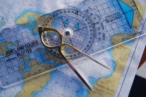
These objects which although tantalisingly evocative and highly romantic to me in my initial state of utter ignorance, have now started to become, as is necessary for a navigator, mundane extensions to our eyes and hands. In the twinkling of an eye I can now rotate the plotter to a ‘True’ bearing and plot a course to follow in what would be the ‘real world’ outside the training room. I can adjust the lovely brass/stainless dividers to the scales at the borders of the chart to prick off distances in nautical miles.
As you can see from the photo above, the plotter is well-signposted with directional arrows indicating the direction of bearing and the direction of North. The whole art of using the plotter depends on pointing the instrument the right way from start point to end point. Then a convenient one of the many references lines in the sliding compass part can be aligned exactly with north-south, or east-west rules on the chart, ensuring ‘North Up’. This enables a bearing value aligned with the large zero point to represent a number that you would see (after adjusting for variation, etc) on a real compass mounted in the binnacle or hand held in the boat.
Get this right and you can start to be a navigator – one who can find his way in the trackless ocean by funnelling planetary measurements, via the chart, into the course to steer.
Romantic? I can hardly breathe with my excitement! However, a more sober approach is really required if I am to become a reliable skipper. A very methodical approach is needed as an initial error can quickly turn into a very big problem as its effect is magnified by later calculations thus rendered utterly false. My chart work will have to be undertaken with as much religious accuracy as befits a Japanese tea ceremony.


Post a photo of this bearded wonder. Proof is required!
You have always yearned to understand and use these navigational instruments with accuracy and now you can and will! No steering off course any more.
Xx